
Outback
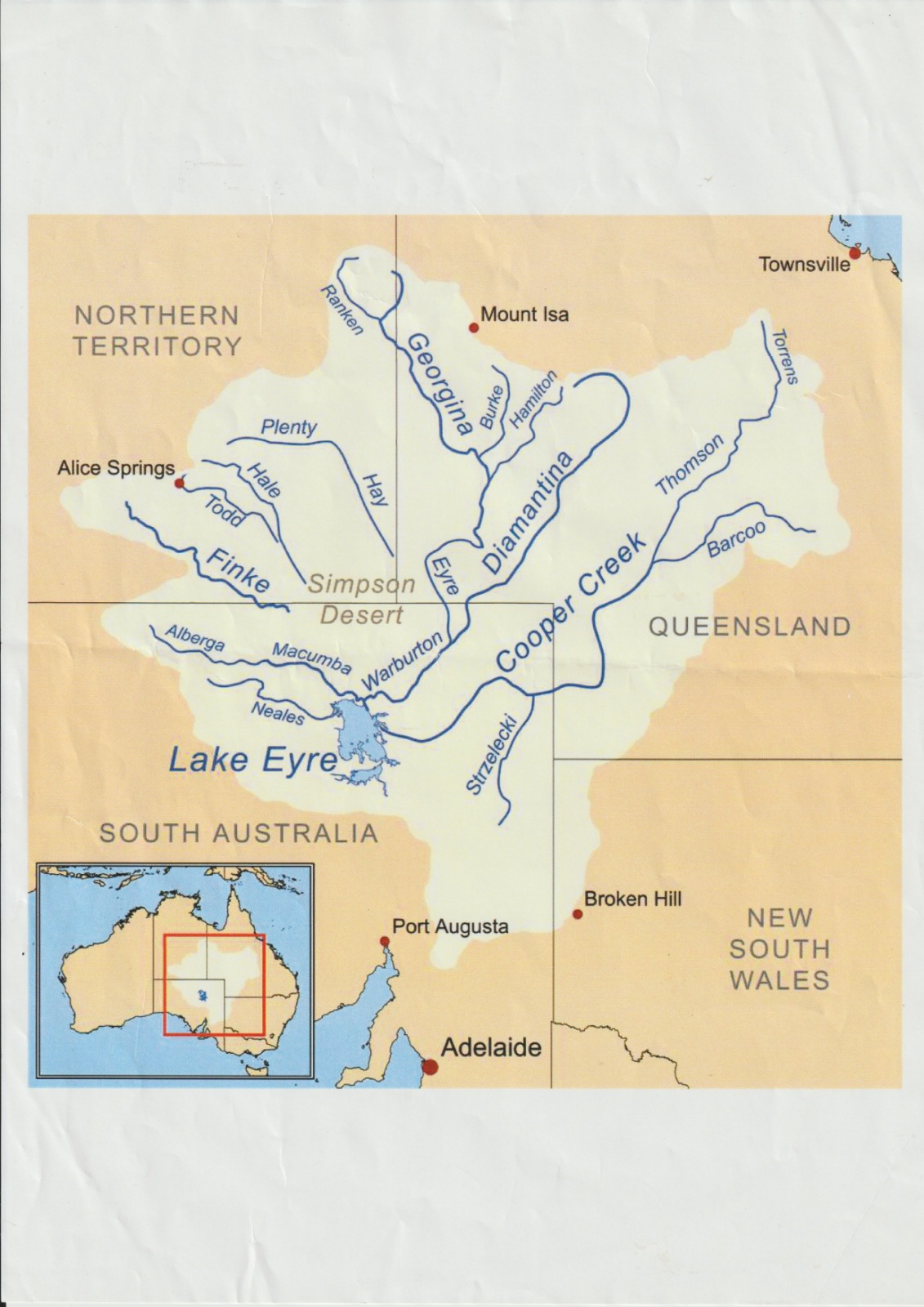
The mighty Georgina and Diamantina Rivers begin their journey in Queensland, slowly winding through the vast Channel Country before eventually reaching Kati Thanda – Lake Eyre hundreds of kilometres away. Every flood transforms this seemingly endless desert into a thriving landscape, filling waterholes, awakening native wildlife and bringing life to one of the world’s most remarkable ecosystems.
From the air, it’s easy to see why this is one of Australia’s greatest natural wonders, an intricate network of braided channels caring their way across the red earth, connecting the outback in spectacular fashion.
Nature works on its own timetable and when the water arrives, it is nothing short of extraordinary.
KATI THANDA – LAKE EYRE SAFARI
18 & 19 September 2025
Leaving from Bankstown Airport, Sydney we headed to the remote William Creek on the Oodnadatta Track with refuelling at Cobar and Broken Hill. Lunch at the local iconic pub followed by a flight over Anna Creek Station to the stunning sandstone Painted Hills, only accessible by air and have recently opened for ground touring, covering an area of 10 by 30 km the multi-coloured pristine sandstone hills of varying shapes and sizes emerge suddenly on top the flat desert landscape. The deep red hills are believed to be due to the oxidation of iron in the rocks, while the white section are where iron has leached away.
Anna Creek Station, established in 1863, is Australia’s largest cattle station and covers around 30,114 sq kms, running around 20,000 head of cattle and 500 working horses. A gibber plain is covered with small, rounded rock fragments called gibbers. These rocks result from weathering and erosion, contributing to the distinctive, rocky terrain of arid regions. The flies were the worst I have ever experienced.
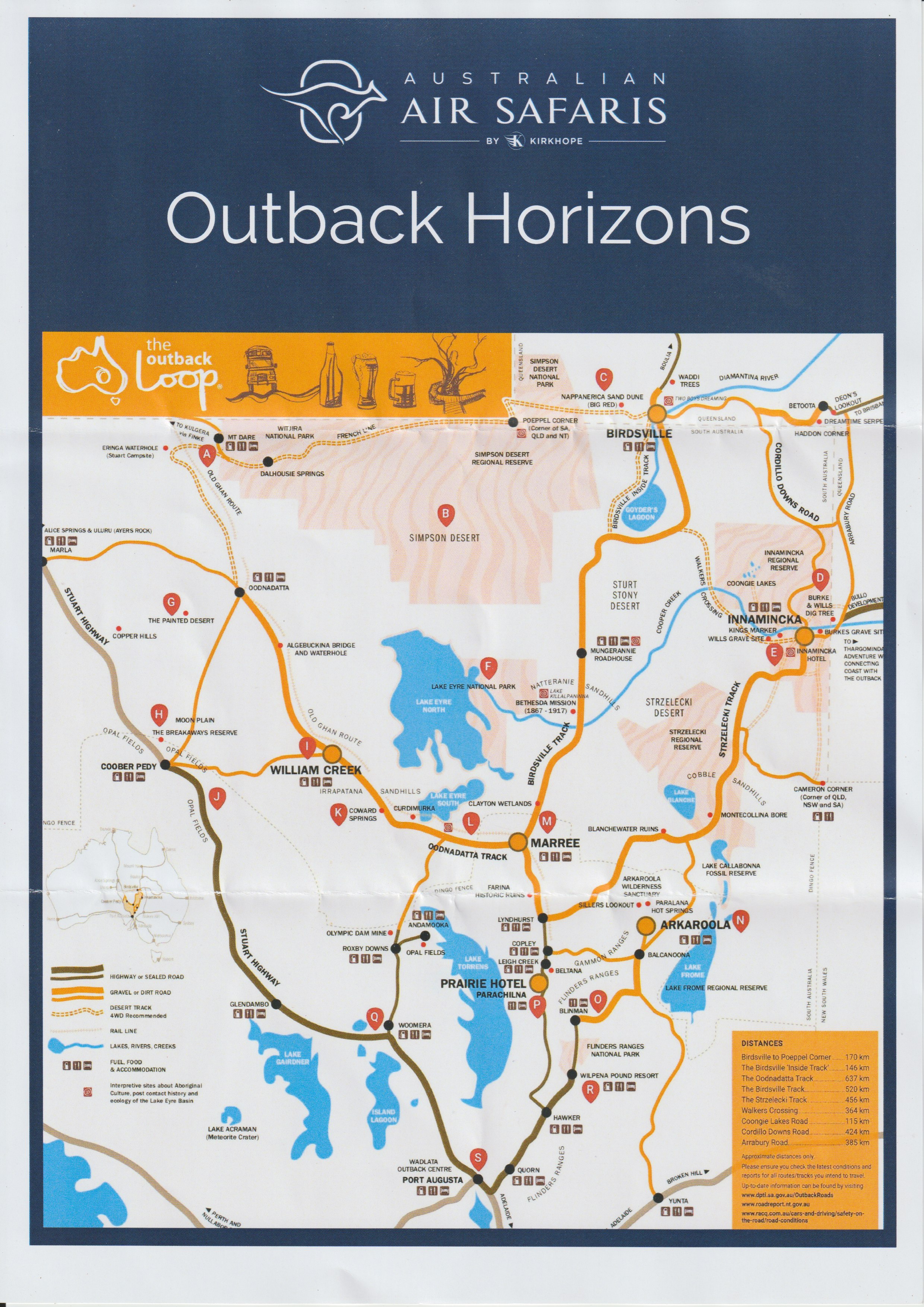
The Oodnadatta Track runs 645 km linking Marree in South Australia to the Stuart Highway at Marla, passing Kati Thanda – Lake Eyre. Travelling through Oodnadatta and William Creek, in the footsteps of of the cattle drovers, relics of Overland Telegraph Line, many historical sites and the Great Northern Railway, parallel to the Old Ghan Railway. Covering flat terrain of the desert sand ridges and gibber plains with little grand scenery there is an amazing sense of space. Beneath the waterless plains lies the immense Great Artesian Basin. Emerging along the track’s edge, the basin surfaces, forming oasis springs that attract diverse life, industries and tourists. The track traverses traditional lands of the Kuyani, Arabana and Arrente Indigenous groups.
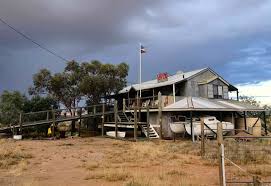
Staying overnight at William Creek, population 10 is South Australia’s smallest town and is the closest town to Kati Thanda – Lake Eyre North, where the rain is measured in drops and the local bore water is fit only for sheep and cattle. The William Creek Hotel, built in 1887 as a support station for camel drivers working on the Overland Telegraph Line, the exterior appearance of corrugated-iron cladding hides the friendly haven inside. The hotel is filled with many strange things and out the front a parking meter collects donations for the Royal Flying Doctor Service.
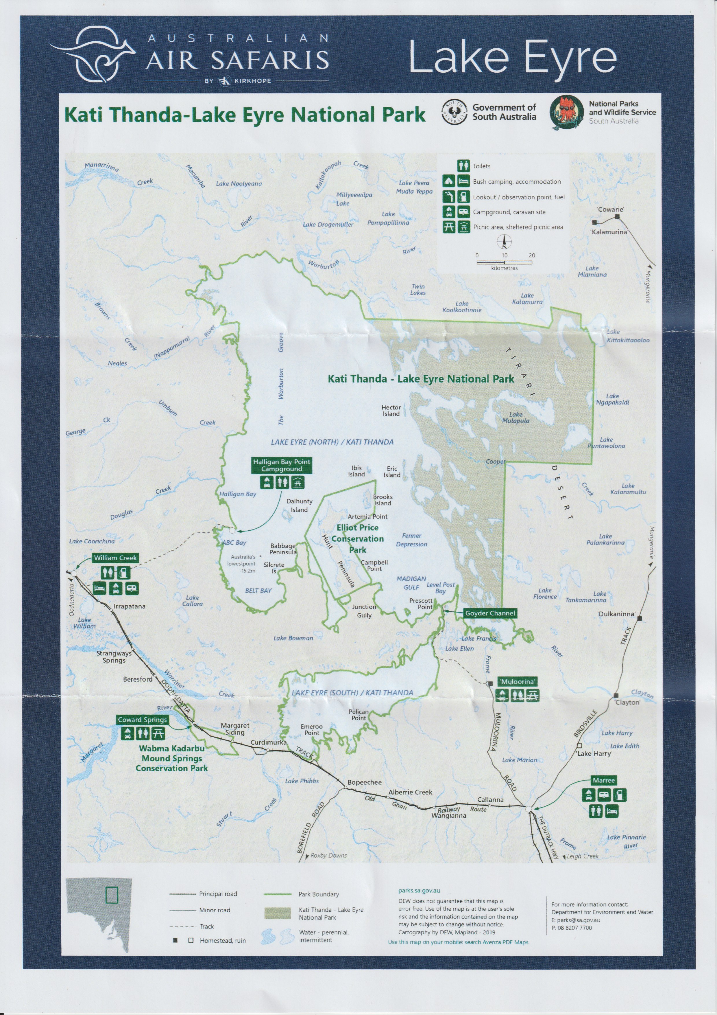
After breakfast it was a short walk to the airstrip where for our flight over Kati Thanda – Lake Eyre the traditional home to the Arabana and the Dieri People. We flew over Belt Bay the deepest part of the Lake, Madigan Gulf, the sand islands and Warbuton Inlet then onto the mystical Marree Man, discovered in 1998. The 3.5km long artwork depicts a hunter with a stick or boomerang. The origin and creator/s are still a mystery although there are plenty of theories. Flying over the mystical Marree Man, only discovered in 1998. The 35km long artwork depicts a hunter with a stick or boomerang. The origin and creator/s are still a mystery although there are plenty of theories.
Kati Thanda – Lake Eyre, the world’s sixth-largest lake is two lakes, Lake Eyre North and Lake Eyre South joined by the narrow Goyders Channel. The north lake covers a massive 144km by 77km expanse and holds the distinction of being the lowest point in Australia, 15.2 metres below sea level. It is Australia’s largest salt lake with a catchment covering three states, covering a total area of 9700 sq km and the entire lakebed is included within the 13,500 sq km Kati Thanda – Lake Eyre National Park. The lake is a shallow, endorheic lake, or sink lake, meaning that the accumulated salt-water lacking an outlet, simply evaporates in the warm outback climate, leaving behind heavy salt deposits on the lake floor.
The lake receives significant flooding about once every eight years due to heavy rains over central and western Queensland, taking only a two years or so to evaporate. Most of the time the lake is little more than a flat, blinding expanse of white sale crust when water is flowing the lake becomes a vast breeding ground for swarms of pelicans, seagulls, terns and many other water birds being a rare celebratin of life in the desert.
On our way back to Sydney we flew over the majestic Wilpena Pound in the magnificent Flinders Rangers before landing on the dirt airstrip for a country lunch at the Woolshed, Rawnsley Park Station, a 3000 hectares sheep property.
Wilpena Pond, cherished as Ikara by the Adnyamathanha people, signifies a ‘meeting place’ is one of the natural wonders of the Flinders Rangers. For over 800 million years, this natural amphitheatre has stood as a stunning peological marvel, 11km long and 5km wide. . Legend speaks of its walls formed by two Akurra (giant serpents) from Yura Muda (Adnyamathanha Dreaming). These serpents, having consumed many, chose self-willed demise when too full. ‘Wilpena’ is an Indigenious word meaning ‘the place of the bent finters’ or ‘a cupped hand’.
The spectacular Flinders Rangers in the heart of South Australia provides a different vista to the long straight roads and distant level horizons. The Adnyamathanha, meaning ‘hill people’ have inhabited the Flinders Rangers for many thousands of years. The Flinders Rangers provides one of the world’s most outstanding insights into the changing geology of 650 million years of Earth’s history, early life and the formation of the Ranges. Dotted amongst the hills and valleys are important archaeological sites including ochre quarries for ceremonies decoration, rock quarries for tools, and art site rich in engravings or petroglyphs, a form of art.
The Flinders Rangers presents the world’s finest record of the rise of animal life – the Ediacaran fossils. The fossils found here are unique in their state of preservation. They included the most diverse life forms and are an exceptional snapshot of live on the ancient seafloor some 550 million years ago.
Dickinsonia is an iconic species found worldwide and named after Ben Dickson, then Director of Mines for South Australia.
The Ediacaran fossil of Spriggina floundersi – is an iconic Ediacaran fossil and may be the earliest animal with a brain. It is named after Reg Sprigg, who first discovered the. fossils in the Edacara Hills in 1946.
Ajax Hill is the historical discovery site of archaeocyath fossils in the Flinders Rangers. Archaeocyaths are early Cambrian sponge-like skeletal marine organisms that produce the earliest known framework animals reefs, with those at Ajax Hill forming about 540 million years ago. Ajax Hill is not only the type locality for the great majority of described Australian archaeocyath species and genera, but also represents the most species diverse archaeocyath locality worldwide.
Our fuel stops included Leigh Creek, Broken Hill and Dubbo before flying into Bankstown Airport, Sydney where I had amazing views of the cities lights over the aircraft dash sitting next to the pilot.
OUTBACK HORIZONS
25-29 April 2025
25 -29 APRIL 2025
Exploring parts of our unique outback following the Queensland flooding as waters move down the Channel Country towards the salt flats of Kati Thanda – Lake Eyre.
FRIDAY 25
All ready for take off from Bankstown Airport and the fog had other ideas so we returned to the departure lounge before taking off about an hour late.
Due to weather our overnight stay at Mungo National Park was changed to Mildura. This was my second attempt to visit Mungo National Park, when asking about the best time to visit March/April was the reply. As it happens my first trip was organised for March and this one for late April, so not convinced about the timing.
We refuelled at Griffith which lead to conversations about the notorious illegal drug trade, particularly marijuana, and organised crime in the area.
As disappointed as we were about not visiting Mungo National Park we were welcomed to Mildura with the best sandwiches for lunch, a drive around the local area and a visit to the arts centre before dinner. It was one of the best steaks I’ve ever had at the The Spanish Grill and excellent breakfasts at our accommodation the Mildura Grand Hotel’s. Do I admit that they also served my desert in a takeaway container which I enjoy in my room. Sadly my room overlooked the internal space full of shabby air conditioning and other hotel infrastructure.
SATURDAY 26
We flew to outback mining town of Broken Hill ‘the Hill’, one of the world’s largest silver-lead-zinc mines discovered by Charles Rasp in 1883, the richest deposit of its type ever discovered. In the 1890s a town of a population of 20,000 now past its peak and has remained a tourist destination being the only town of significance in the area. The largest town in western New South Wales, Sydney is nearly 1200km to the east, Melbourne is 900km to the south, Adelaide over 500km to the south-west and is the closest capital city.
I visited with Dad in 2010 and even though in New South Wales it is on South Australian time. We were meet by our tour guide, Clark Barrett taking us to our first stop at the famous Bells Milk Bar to enjoy a drink of our choice, mine was a sarsaparilla spider, just how I remembered it.
Lots of work has been done providing an excellent visitor museum at the Royal Flying Doctor Base though I was very disappointed to find the viewing deck of the aircraft hanger has been lost.
We visited Silverton, 21 km north-west of Broken Hill, the operational centre for a number of films including Max Max. Later we enjoyed a late afternoon at the spectacular Desert Sculptures overlooking the expansive landscape, a visit to the Palace Hotel made famous by Priscilla, Queen of the Desert followed by an excellent dinner at Trinders Restaurant which I would highly recommend if your ever in Broken Hill. If you do not mind some easy steps the Royal Exchange Hotel is worth considering for central location accommodation with great views from the large, expansive balcony.
SUNDAY 27
We explored the Broken Hill mines including the Browne Shaft, the Line of Loade and the Miners Memorial remembering over 800 miners who have lost their lives on the job before heading to Innamincka for lunch.
We flew low over Cooper Creek and the junction of the Strzelecki Track where the Burke and Wills Dig Tree was nestled in amongst the flood waters and place of their ill-fated expedition before landing at the tiny outback town of Innamincka in South Australia’s remote northeast. On the banks of the Cooper Creek it owes its beginnings to the government’s customs post which taxed all the stock travellin from one colony to another. While at Innamincka, on Cooper Creek a Black Hawk helicopter landed delivering supplies to the town cut off by floodwaters.
The Yandruwandha people, Innamincka’s traditional owners named it ‘Yini mingka’,meaning waterhole. Charles Sturt (1845) and Augustus Gregory 1(1858) explored the area before the tragic Burke and Wills expedition of 1860-61 further highlighted Innamincka’s historical significance.
Close to the Queensland border Innamincka owes its beginnings to the government’s customs post which taxed all the stock travelling from one colony to another. With the. advent of free trade between the states as a result of Federation, the. customs post went in 1901. Later becoming a part of John Flynn’s establishment of the Royal Flying Doctor Service. By the 1950’s the town was deadwith a couple of the stations around the area claiming the. remains with the pub becoming a stockmen’s quarters for nearby Innamincka station. In the 1960’s saw the search for oil and gas and big strikes of both the surrounding dune country.
When travelling by road from the Natterannie Sandhills the Cooper Creek flood plain is five km wide at the road crossing with its abundance of spreading coolabahs. Rising in the central highlands of Queensland and by the time its floodwaters flow into Lake Eyre they have travelled about 1500km.
After flying over the Goongie Lakes we headed to Birdsville, along the Northern Territory border, population of 110, staying at the Birdsville Hotel across the road from the airstrip. There was no internet and limited television channels so thought about writing my postcards until I realised I was unable to access my addresses and no phone to ask for address, there was a bible in my room. What to do? I went for a walk along the very wide empty streets with not another person or car in sight due to Birdsville being cut off from the flooded roads with only air access.
Birdsville, on Wongkanguru land and Queensland’s most isolated town only 14km from the Queensland border on a barren, stoyy rise overlooking the Diamantina River and the Munga-Thirri, Simpson Desert. Best know for heat waves of temperatures of 50º C, its association the Birdsville Track in the Channel Country. The town was originally established in 1881 as a customs post to collect tolls on cattle moving between Queensland and South Australia, but these were abolished after Federation in 1901.
We were given permission to travel off road due to flooded roads for our 4WD drive adventure to the Big Red on the edge of the Munga Thirli, Simpson Desert, one of the world’s outstanding sandridge deserts where we overlooked the vast expanse of dry lakes, gibber plains and lesser dunes. The first of 1,140 parallel sand dunes marking the edge of Munga Thirli, Simpson Desert, known as the Nappanerica Sand Dune this 40m-high dune is said to be the desert’s highest.
Wondering about the small fenced paddock my thoughts were answered when it was explained that it was used to monitor the landscape conditions. This lets the station know about the feed conditions of the area so cattle stock numbers can be monitored on the large stations.
The Simpson Desert, Munga Thirli sprawls across more than 150,000 sq km at the junction of the Northern Territory, Queensland and South Austrlaia with remarkable parallel dunes rising to 40m and stretch without a break for up to 200km. Running from south-south-east to north-north-west with the direction being maintained by the prevailing winds.
MONDAY 28
Boarding our aircraft, after a short 5 minute walk from our accommodation, we flew over the Diamantina River, Goyder Lagoon, and the Warburton River that are part of the Channel Country which is flooding from the recent very heavy Queensland rains. After seeing the Marree Man we continued our flight over the dry, flat salt-plain Kati Thanda – Lake Eyre, traditional home to the Arabana and the Dieri People. We flew over Belt Bay the deepest part of the Lake, Madigan Gulf, the Sand Islands and Warbuton Inlet.
Lunch was at William Creek on the Oodnadatta Track, one of the most remote out back towns in Australia and with a population of fewer than 20, before seeing more of Kati Thanda – Lake Eyre from the air and heading to the Flinders Rangers.
Often the only sign of human habitation are kilometres of straggly wire fences and the occasional silver galvanised roof of a homestead or outback shed.
Landing at Balcanoona Airport, the main ranger station for the Gammon Rangers National Park, it was a 30 minute drive to our overnight accommodation at Arkaroola Wilderness Sanctuary, which has a focus on conservation, education and science. Sadly I was very disappointed with their star gazing tour of the millions of stars that are visible here due to the lack of artificial light opening up views of our galaxy and beyond.
Arkaroola Sanctuary & Resort, established in 1968 when Reg Sprigg took over the 61,000-hectare station lease. Over the years the rampant feral goat and rabbit populations were brought under control, there was no more sheep and the area’s flora and fauna have thrived. The South Australian Government is pursuing a nomination for Wold Heritage for parts of the flinders Rangers for its outstanding geological, paleontological values and biodiversity.
The ancient rocks found within the Arkaroola Protection Area provide a window into deep geological time and contain the evidence of significant geological phenomena, including the fossilised remains of an ancient geothermal system, sponge-like animals forming barrier reefs and glaciers. Arkaroola has been managed for conservation and research for over 50 years and was called ‘one great open-air museum’ by Antarctic explorer, Sir Douglas Mawson.
Local Indigenous People of the Northern Flinders Ranges are made up of different clans; Walpi, Kuyani, Yadliaura, Vanggarla and Biladappa. Recent archaeological evidence identifies that the Adyamathanha people have lived in the region for at least 49,000 years. Their Yura Muda (Adnyamathanha Dreamtime) says that Arkaroo, a large serpent, drank Lake Frome dry, then crawled up into the mountains, his movements created Arkaroola Creek and the waterholes.
TUESDAY 29
After deciding not to do the 4WD Ridgetop Tour to Sillers Lookout I arrived for breakfast when people were ready to depart and spontaneously confirming that I could sit in the front I excitedly joined the tour with some fruit for my breakfast.
The Flinders Ranges, a glorious environment of ochre tones, vivid contrasts, hidden treasures, indigenous rock art, elusive wildlife, robust plant life and panoramic vistas.
The Northern Flinders Rangers are home to over 160 species of birds, the endangered yellow-footed rock wallaby and a vast landscape of geological monuments, rugged mountains, granite peaks, magnificent gorges and mysterious waterholes.
We headed home via Lake Frome with an excellent pre-packed picnic lunch to enjoy during our long flight. Refuelling stops were at Broken Hill and Dubbo where we had a delayed departure due to 3 medical flights landing before a night landing at Sydney’s Bankstown airport. Thank you to our pilot, Callum Jones for our wonderful adventure.

KATI THANDA-LAKE EYRE in flood
From Australian Air Safaris June 2025 eNewsletter
Water is still flowing strongly into Kati Thanda–Lake Eyre — an incredible reminder of just how vast and slow-moving this remarkable system is.
Queensland experienced three major flood events in 2025:
• The North Queensland floods in late January
• Cyclone Alfred in late February
• And most significantly, the Western Queensland floods from late March to April — the only one feeding into the Lake Eyre Basin.
So why does it take months for the water to reach the lake?
For starters, it may travel over 1,000 kilometres from the floodplains of Western Queensland. Add to that the fact that the Lake Eyre Basin is one of the flattest drainage systems in the world — with some rivers falling as little as 10 to 15 centimetres per kilometre. That’s barely a slope! It’s a slow, meandering journey across desert floodplains. That so much water can traverse such a harsh and dry continent to create a fleeting inland sea in the centre of Australia is truly one of nature’s great spectacles.
Even now, the Cooper Creek continues to flow, recently cutting the iconic Birdsville Track — and it’s still on its way to the lake. Significant inflows are expected in the coming weeks, and current predictions suggest water will remain in the lake until at least Christmas.

This book ‘No Roads Go By’ by Myrtle Rose White was in the van of our Broken Hill tour guide, Clark Barrett. Even though I have not read it, this books looks well loved and very interesting.

Floodwaters are beginning to fill Lake Eyre
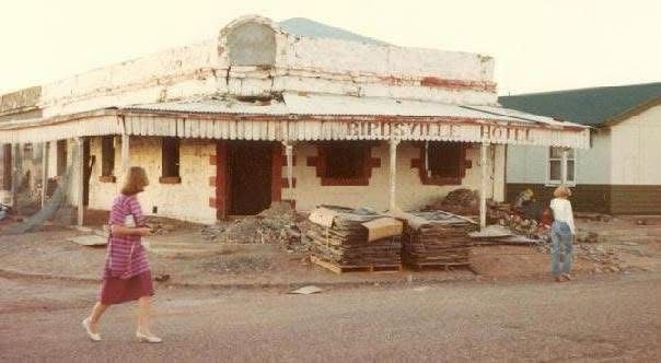
The Birdsville Hotel in the 1970’s photo Les Batros


A photo of the Birdsville Hotel in my Australian Heritage cookbook

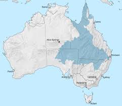
AUSTRALIA’S GREAT ARTESIAN BASIN

SE Qld Weather Photography -Chris McFerran
